Gold Strike Canyon, Boulder City, Nevada

Natural Hot Spring

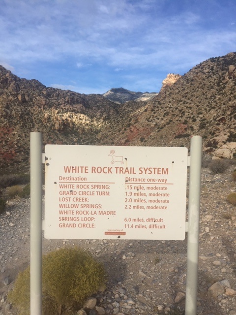
Location: Gold Strike Canyon, Boulder City, Nevada – The trail head is located right off Highway 93 near the Hoover Dam exit. Click here for a map of the area. There are signs that lead you to Gold Strike Canyon from the highway just be on the lookout. It is free to park and there is no fee to gain entrance to the canyon!  

This trail is closed from approximately mid-April/May to end of September due to extreme heat. It is no surprise that Las Vegas hits 100 + degree weather, but the heat at Gold Strike, gives “blistering heat” a whole new meaning. Several people have died due to the extreme weather and failure to properly prepare for the hike so be sure to bring plenty of water. On that happy note, let us get into the hiking deets!

Water Station to Donate Leftover Water

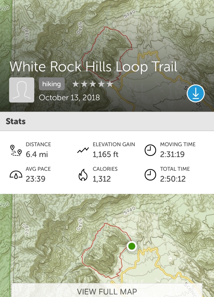
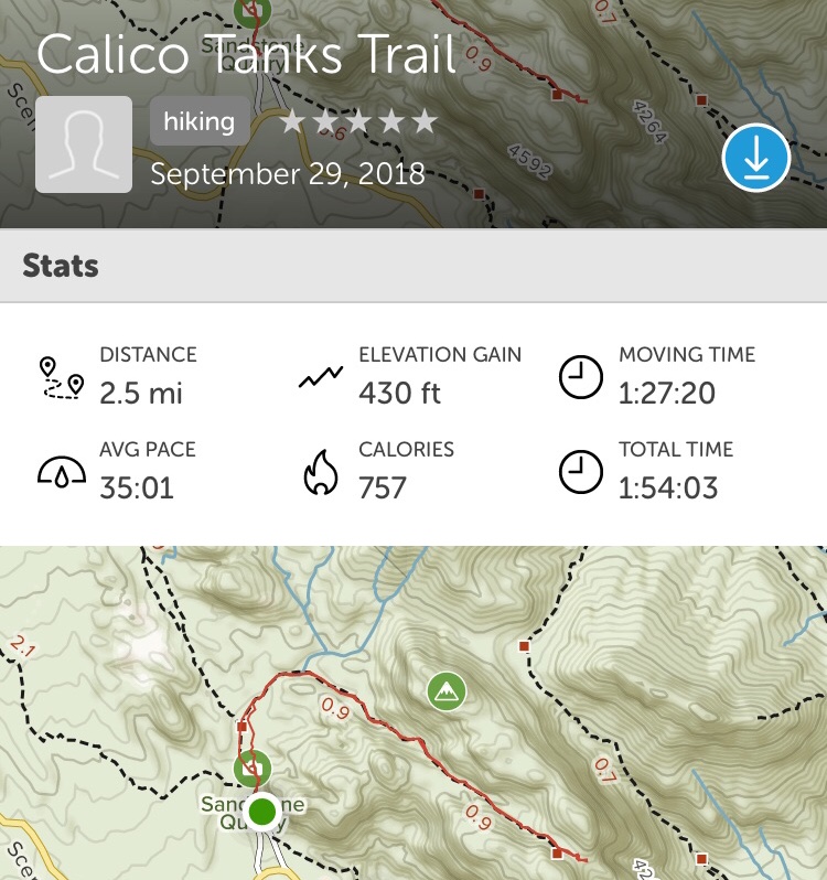
Distance: According to Alltrails this hike took us 7.4 miles to complete. If you are looking for an adventure, this is the perfect hike for you! This hike will have you trudging through sand, scrambling over rocks, climbing up and down ropes and trekking through water.

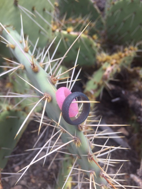
The ropes are a unique and fun addition to this hike but we advise caution when using them. One member of our group used a lackadaisical approach and ended up flat on her butt with a nice rope burn down her arm.

While the ropes are fun, the main draw include the natural hot springs along the way! You can relax and soak in the hot springs but, whatever you do, do not put your head under the water! According to the Centers for Disease Control and Prevention, there are Naegleria fowleri (aka “brain eating amoebas”) that live in hot springs. These amoebas gain access to our brains through our nasal cavity. From there, the amoeba swim directly to the brain and eat away at its tissue. And you thought you only had to worry about the extreme heat!

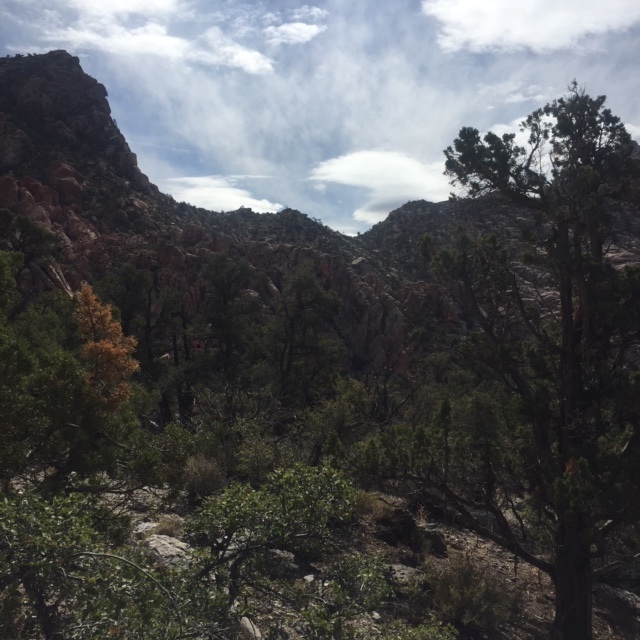
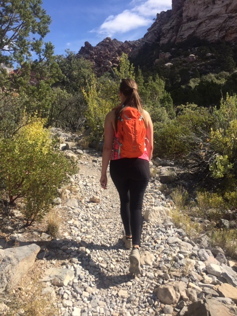
In addition to the hot springs, there is endless beauty on this hike. We took our time taking pictures, hanging out with good friends, and enjoying nature. 

Hiking truly is our outdoor therapy from all of our everyday problems. I recently read a Times article written by Jamie Ducharme that discussed the benefits of Forest Bathing. I was thrilled to see the concept of Forest Bathing reach a wider audience than it has been given in past. The article is titled “A Prescription You Can’t Fill at the Pharmacy” and it focuses on the prescriptions that can only be filled by mother nature. 

The article identified six benefits of being in the great outdoors. I am paraphrasing but the gist of the benefits are as follows: 

  • Relaxation: Spending time outside can decrease cortisol levels and lower blood pressure.
  • Physical Activity: Being outside promotes movement which is beneficial to our overall health. 
  • Social Support: Parks and hiking trails create social settings which force interaction with strangers. This can defend against loneliness if one is willing to engage their fellow outdoor mate. 
  • Mental Health: Research has shown that nature can elevate one’s mood and reduce symptoms tied to depression and anxiety. 
  • Awe: Taking in mother nature’s beauty can spark feelings of generosity, perspective and selflessness. 
  • Fresh Air: Breathing in clean air reduces some of the risks associated with respiratory problems. 

More doctors are beginning to understand the health benefits of Forest Bathing and are writing their patients nature prescriptions. In fact, one Pediatrician in Washington, D.C., Dr. Robert Zarr, founded Park Rx America to provide ease to other physicians in writing “park prescriptions” to patients of all ages and sizes. 

Returning to our hike, the above pictures are where our hike ends, at the base of the Hoover Dam. Generally the waterline is up considerably but this year it is very low. The water seen in these pictures are part of the Colorado River. During the Spring time you will encounter several companies that do guided kayaking tours on this part of the river. This is generally the spot where they will get out and have lunch before heading back. This part of the river requires a permit to be on and they are hard to come by which is why most people opt for the guided tour. 

Last, but not least, on our way back to our vehicles, we spotted a great horned sheep! I captured a picture of it on top of the rocks, albeit not a good one. It was the last picture I took before my phone powered itself off. 

This upcoming weekend we are looking into new locations to hike around Las Vegas so be sure to check back for new posts!

Turtlehead Peak, Las Vegas, Nevada

TH The Climb

Location: Turtlehead Peak, Red Rock National Park, Las Vegas, Nevada – Click here for driving directions.

The park is open year around and there is a fee to gain access. The prices vary from $5 per pedestrian/bicycle to $15 per vehicle. You can visit their website here for more details on pricing. If you are a frequent hiker of National Parks, consider getting the America is the Beautiful Pass. It is absolutely worth the $80 annual fee.

Distance: Red Rock has this trail marked at 4.6 miles and strenuous which is not an understatement. You will gain nearly 2,000 feet in elevation during this hike. We ended up going 4.8 miles but that is merely because we went rogue on part of the trail. It is easy to get off the path on this hike but if you look for the orange spray paint on the rocks you will stay on track.

TH Alltrails.jpg

The Climb: Suggestion, do not do this hike shortly after you have had a flu shot – it does not go well. I was drenched before we even hit the half-way mark. The remainder of the climb up was shaky, at best, but I survived. Turns out, not wanting to disappoint your fiancée after she has been cooped up studying all week, was a great motivator for pushing forward.

Aside from, “I may throw up” and “I am not feeling well,” there was not much discussion on the way up to the peak. However, once we made it to the top there was a little someone who instantly took my mind off the sickness. Without further adieu, let me introduce you to our little friend, Marvin. This little guy was quick to befriend us. I am certain it had everything to do with my charming personality.

We spent a good bit of time relaxing at the top and taking in the gorgeous sight around us. If you are into photography or art, this would be the perfect place to set up shop and get creative.

TH Grand View

We spent the rest of our hike discussing our wedding details. The plan is to elopement in Iceland in the great outdoors next September. I am pushing for a cave wedding and she wants the waterfall wedding. It appears that mother nature will be the tiebreaker so be sure to continue following our blog to find out which spot she has chosen for us.

After the Thanksgiving holiday we will be able to return to our usual hikes. The fiancée will be free from CPA studying on November 20th – let the countdown to freedom begin!

Dale’s Trail, Las Vegas, Nevada

Dales Yoga T

Another week of hiking, another week of Red Rock National Park. Fortunately, my fiancée* only has two more weeks of studying for her CPA exam and then we will be free to travel and mix up the hiking. *Fun Fact: “fiancée” is used when a female is engaged to be married and “fiancé” is used when a man is engaged to be married.

Location: Dale’s Trail, Red Rock National Park, Las Vegas, Nevada – Click here for driving directions.

The park is open year around and there is a fee to gain access. The prices vary from $5 per pedestrian/bicycle to $15 per vehicle. You can visit their website here for more details on pricing. If you are a frequent hiker of National Parks, consider getting the America is the Beautiful Pass. It is absolutely worth the $80 annual fee.

Distance: Red Rock has the trail listed at 4.0 miles but it took us 4.6 miles according to AllTrails. We tend to end up off the trail at times but we call it an adventure and embrace the extra caloric burn.

Trail: You can start this trail from two different locations – Pine Creek or Ice Box Canyon (click here for details). We have done both and we prefer to start from Ice Box Canyon.

The trail is easier to follow from Icebox Canyon. We may or may not have gotten lost when we started from Pine Creek. If you are ever lost, look for these Cairns. Cairns (aka trail markers) are rocks that are stacked on top of each other by fellow forest bathers to guide others to the correct path.

This trail does not appear to be all that interesting but there is so much to see during the out and back trail.

We loved this area with the red dirt and there was even a random bench to sit and relax on or use as a photo prop. Further ahead there was this unique “skull rock.” If you view the rock head on as opposed to this photo angle, you will see the skull much better.  Dales Skull Rock

To our surprise, we saw more body parts along the way. We found this bone sitting on top of a rock. We took a picture and sent the image in to be identified. According to our specialist, this is a section of lumbar vertebrae from an ungulate such as a deer or sheep.    Dales Bone

The Great Debate: Should We Adopt China’s Social Credit System?

China is in the midst of implementing a social credit system wherein it attempts to modify its citizens’ behavior through use of a social score to create a problem free society. Similar to a credit score, favorable behavior would increase your social rating and unfavorable behavior would decrease your social rating. Continued negative behavior will result in a citizen being “blacklisted.”

The consequences of being blacklisted are not clear but it appears the goal is to publicly shame its citizens and make it nearly impossible for them to conduct business in China. The fear of being blacklisted is intended to be the driving force toward positive and respectful behavior thus creating a safer and improved society. Currently, the social system is in its testing phases but the goal is to have it implemented across the entire country by 2020.

We debated this topic for a good portion of the hike and ultimately decided that we would be against a social credit system. While there are many positive consequences that could result from this system, it does not outweigh the stifling effect it would have on individualism. We do not want to live in a society ruled by fear or disingenuous. It is an interesting concept though and we will be following the news in China to see how things turn out for their society.

Feel free to share your thoughts on the great debate -we enjoy hearing different perspectives.

White Rock Springs Loop, Las Vegas, NV

  Loop Views 2

Location:  White Rock Springs Loop, Red Rock National Park, Las Vegas, Nevada – Click here for driving directions.

The park is open year around and there is a fee to gain access. The prices vary from $5 per pedestrian/bicycle to $15 per vehicle. You can visit Red Rock’s website for more details on pricing. As indicated in our prior posts, if you frequent National Parks consider getting the America is the Beautiful Pass. It is definitely worth the $80 annual fee. There are some individuals who can obtain the pass at a discounted rate and if you serve in the military, you can get a pass for free. Check out this website for all the details.

Distance: Red Rock’s sign indicates 6.0 miles roundtrip but according to Alltrails it took us 6.4 miles to complete the loop.

                                 Loop Sign

The Loop: We have done this hike several times as it is one of our go-to hikes. We prefer to start the loop at the White Rock parking lot but you can access this trail from several parking lots (check out this helpful map). Insider tip, drive all the way up the dirt path to the upper parking lot as opposed to parking at the bottom. From the upper parking lot, there are two trail heads to start the loop. We prefer the trailhead closest to the restroom so that the loop can be done clockwise. This allowed us to hike in the wide open part of the trail earlier in the morning and on the more covered parts of the loop when the sun was at its highest point.

As you make your way around the loop, you will cross into the Willow Springs Picnic area and the La Madre Springs trail. If you packed a lunch, this is the perfect place to stop and enjoy the meal.

Loop Picnic            

The rest of the loop can be done at a leisurely pace or if you are inclined, you can do some trail running. We typically like to use the last mile or so to trail run. We would suggest paying close attention, though, because there are spots with loose rocks. For the more leisurely parts of the trail, we used the time to discuss life, per the usual. It is part of our forest bathing process to unload the mind and cleanse the soul. Below I have detailed one of our more interesting topics of discussion.

Loop View with T 2        Loop View with L

Realism vs. Optimism

Discussing life while hiking in the great outdoors can be quite cathartic. During this hike, my fiancée and I discussed the concept of realism versus optimism as it relates to expectations and relationships. Realism meaning, “the attitude or practice of accepting a situation as it is and being prepared to deal with it accordingly,” and optimism meaning, “hopefulness and confidence about the future or the successful outcome of something.” The question for us became, is it better to be optimistic or realistic when it comes to managing expectations and our relationships.

Before I get into the logistics of our discussion, it is important to understand what led to the conversation begin with. If you read the “About Me” section, you will discover that we are a lesbian couple. We recently became engaged which I discussed in our Pine Knot Trail post. We, of course, have been thrilled about our engagement but that has not been the case for everyone in our lives. Our engagement has brought out strong feelings on both sides of the isle. We have received unhesitating congratulations accompanied by unconditional love contrasted by dead silence, leaving us to wonder, were there conditions for us to be loved? Needless to say, it has been an emotional roller coaster at a time in our lives when we should be celebrating our love.

We started asking ourselves, should we remain optimistic and hopeful that with time and exposure people will come around to our engagement? Alternatively, should we be realistic and succumb to the fact that our relationship may always be at odds with an inner belief system that we simply cannot compete against? If we choose realism, does that, in and of itself, have a negative connotation that puts it closer on the spectrum to pessimism thereby foregoing optimism altogether? Good thing this hike was over six miles, we had a lot to discuss.

We ultimately decided that relationships were all about managing expectations and in setting expectations you needed realism. In the past, I struggled with setting realistic expectations for those that I loved because I expected those individuals to fill roles they were incapable of fulfilling. I discovered that merely holding a title – father, mother, sibling, etc. – did not equate to success in that particular role. I suffered continued heartache and disappointment because I failed to acknowledge and account for these shortcomings in my relationships. It was not until I learned to redefine relationships and insert realistic expectations that I was able to break free from this disappointing cycle.

It took a great deal of effort to redefine my relationships (and it is a continued process) but it has made a marked difference in my overall mental health. The concept of redefining is quite simple – assign your family member a new role and ensure it is a role they are capable of fulfilling. For example, if you have a parent who places conditions on their love, reassign them as a “distant cousin.” Using our example above, instead of expecting our parent(s) to accept our engagement with unconditional love, we ask ourselves, would we expect our distant cousin to give us the same unconditional love our parents would? Odds are, probably not. We also would not spend much time worrying why they were not happy for us. Instead, we would shrug it off and move on because while we love our distant cousin, they are not star players in our lives.

It is through this process of redefining that we are able to move forward from the negative reactions of our engagement. While we remain optimistic that others will come around and share in our happiness, we are not naive to the fact that some will not. It is through this realism that we are able to maintain optimism. The reality is that we cannot control others but we can control our reaction to others and we have chosen to be realistically optimistic.

Feel free to share your perspective on the issue of realism versus optimism. Please keep in mind, that while we value others’ opinions, we will not tolerate hatred directed toward the LGBTQ community so please be respectful.

Calico Tanks, Red Rock, Las Vegas, NV

WELCOME TO NATURE’S STAIRMASTER

Calico Stairway

Location:  Calico Tanks, Red Rock National Park, Las Vegas, Nevada – Click here for driving directions.

The park is open year around and there is a fee to gain access. The prices vary from $5 per pedestrian/bicycle to $15 per vehicle. You can visit Red Rock’s website for more details on pricing. As indicated in our prior posts, if you frequent National Parks consider getting the America is the Beautiful Pass. It is definitely worth the $80 annual fee. There are some individuals who can obtain the pass at a discounted rate and if you serve in the military, you can get a pass for free! Check out this website for all the details.

Once inside the park, you can access this trail from the Sandstone Quarry Parking Lot. Here is a map for additional guidance.

Calico Sign

Duration: This trail is officially listed at 2.5 miles but distance can be added through exploration. We had limited time so we kept to the path and AllTrails confirmed it was exactly 2.5 miles.

CT map

Trail Rating:   5 out of 5

We have deemed this trail Nature’s Stairmaster because Mother Nature wants you to have that toned booty you have always dreamed of, too.

CT Wall   CT Other Half  CT Stairs

You will encounter several staircases throughout the hike which makes this trail unique. In addition to climbing stairs, you will also be climbing giant rocks so I would suggest shoes with good traction. We both prefer to wear Merrell hiking shoes. If you are super fit, you can attempt trail running on parts of the trail.

CT Run

Alternatively, you can have your partner take a picture mid-stride so that it appears you are trail running. We promise not to judge so long as you make it to the end view point where you can see the entire Las Vegas Strip. Unfortunately, it was too cloudy to capture The Strip in the picture below but that is all the more reason to get out and try this hike!

CT Strip View

Once you have made it to the top you can relax and enjoy the view. It is the perfect location to have a snack, do yoga or dare I say, propose to the one! In case you have not read our Pine Knot post, my fiancée proposed at the end of that trail and I could not have been happier. It is in nature where we find our greatest peace so it made sense that the beginning of our happily ever after started there too.

If you are not ready for that kind of commitment, do not worry, yoga is still an option…

If you want to know more information, feel free to contact us.

Ice Box Canyon, Red Rock, Las Vegas, NV

Up IB

We set off for a local adventure this past weekend to Red Rock National Park – one of our go-to locations for hiking during the cooler months in the Las Vegas, Nevada.

Location: Icebox Canyon, Red Rock National Park, Las Vegas, Nevada – Click here for driving directions.

The park is open year around and there is a fee to gain access. The prices vary from $5 per pedestrian/bicycle to $15 per vehicle. You can visit their website here for more details on pricing. As indicated in our previous post, if you are a frequent hiker of National Parks, you should definitely get an America is the Beautiful Pass! It is absolutely worth the $80 annual fee. There are some individuals who can obtain the pass at a discounted rate and if you serve in the military, you can get a pass for free! Check out this website for all the details.

Distance: The official distance is 2.2 miles roundtrip according to the park’s website but as you can see in the AllTrails map below, you can add distance to the trail by scrambling different parts of the trail along the way.

                       Official IB Trail    IB Trail

Trail Rating: 5 out of 5 stars

This is the perfect trail if you are looking for a quick hike that still gets your heart rate up. The majority of the hike takes place in the canyon where you scramble over large boulders. The climbing can be strenuous if you are not used to exercising but we saw several people of all shapes and sizes conquering this trail so do not let that stop you!

                       cropped-rocks1-e15376517556363.jpg   cropped-ib-looking-out.jpg

We have hiked this trail several times before and our best advice is to hike early in the morning. This trail is VERY popular and becomes crowded quickly. We arrived at 8:00 a.m. which was sufficient for September (spring is probably a different story). The other reason we suggest hiking early is to avoid the heat. The first part of this trail – before you hit the canyon – is flat ground and in direct sunlight with limited to no shade (see below). If you do plan to hike later in the day, bring plenty of water to stay hydrated and wear a hat!

IB Canyon Front View

Once you get to the end of the trail, there are plenty of places to sit and enjoy a snack. If you are feeling adventurous, you can climb up the canyon wall. I cannot say this portion of the hike ended well – I may have slid down a portion of the upper level wall – but what are a few battle wounds for, if not for a good story!

Climbing Up

Repeat Trail: Yes!

This is definitely a trail worth returning to if you get the chance. The distance keeps it reasonable and the scrambling adds to the hike’s intensity. Whether you are a local or visiting, this is definitely a hike worth doing. If you are looking for a longer hike, I would suggest the White Rock Loop which is also located at Red Rock. That trail is approximately 6.5 miles and is gorgeous! We will be redoing that hike in the near future so be sure to check back!

If you have any questions about this trail, feel free to reach out and ask questions.

Pine Knot Trail, Big Bear, CA

Our bodies were getting restless and our minds overworked. We needed an adventure to restore our sanity! We headed to Big Bear, California where hiking is abundant and the trails were calling our names. Little did I know, the next 7.4 miles would change my life. Let’s get into the deets!

Location: Pine Knot Trail – San Bernardino National Forest, Big Bear, California

Pine Knot Trail

Parking: You must have an America the Beautiful Pass or a daily adventure pass hanging from rearview mirror.

You can purchase daily passes in town for $5.00 per day – checkout this link for more information on the adventure pass. Alternatively, if you frequent national parks like we do, it is worth $80 to purchase an annual American the Beautiful Pass. For more details on this pass, visit this website.

Distance: 7.4 miles to the Grand View Point from the Pine Knot Trail.

We enjoy using Alltrails to map out our trail. As you can see from the image below, this app will track your distance, time, elevation and calories burned. Even better, if you get lost, just follow the red line back to where you started!

Pine Knot Trail

Trail Rating: 4 of 5 stars

The trail was well marked and the path well worn. There was no guess work when it came to where you were headed. Several trails split off from Pine Knot and each split provided an easy to read sign with trail names and distances. We hiked mid-morning but realistically you could hike throughout the day because Pine Knot is shaded off and on throughout the entirety of the trail. This trail can be quite the butt burner but rest assure there are several places to stop and rest along the way!

Surprise Ending: What about Pine Knot changed my life?

Well, in addition to the Grand View Point at the end, I received my dream proposal! I had no idea. It turned out to be a perfect and intimate moment between us and nature. Even the ring box was made from nature! She ordered a ring box made from an acacia tree, found in the steeps of Ukraine. The processing was all natural and she even had our initials carved on the top. Without a doubt, I said YES!

RB2

Would I do this hike again? Yes*

*I will note I am biased toward this trail due to the proposal but if you haven’t had a chance to do this trail, it is still worth it.

If you have any questions regarding this trail, feel free to ask!

Join Us On Our Journey…

Where we head into the forest to lose our minds and cleanse our souls!

Shinrin-yoku is a term derived from Japan in the 1980s and means, “taking in the forest atmosphere.” Over time this term has also become known as “forest bathing.” Forest bathing is the simple medicine of being in nature. It is from this healing process where we can cleanse our souls and emerge an improved self. This blog is our journey through the art of forest bathing.